Product Search
Preston Candover (Village Booklet 74)
The village of Preston Candover and the parish of the Church of St Mary the Virgin...
Supplied by: Hampshire Genealogical Society Product Ref: HAM-16074
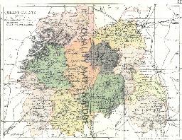
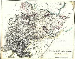
QUEENS 1882
A QUALITY A3 SIZE COLOUR REPRODUCTION FROM PHILIP'S 1882 ATLAS. LASER PRINTER ON GOOD QUALITY CARTRIDGE PAPER. SENT FOLDED IN A PLASTIC DISPLAY SLEEVE IN A STIFF CARD ENVELOPE AT THE LARGE LETTER RATE. SCALES VARY [WATERMARKS WILL NOT SHOW ON PURCHASES]...
Supplied by: Quality Maps and More Product Ref: QMM-MP224
RA 15. Guide to Genealogical Research in Late Victorian and Edwardian London
Revised 5th edition, November 2004) d This is a supplement to RA6, listing parishes founded in the 1870-1903 period. It also covers a wider area than RA6, extending to the whole of the old LCC district, and listing those outer parishes in the same way as RA6 does for the inner ones. It also has a map of parish boundaries for 1903.This new edition also includes a new appendix designed to help one l...
Supplied by: West Surrey Family History Society Product Ref: WSY-RA15
RA 2. Pre-1837 Parish Boundaries in Suburban London
This A3-size map (folded to A5) compliments the county parish maps produced by the Institute of Heraldic and Genealogical Studies, Canterbury. The main use is in planning a search pattern if an ancestor does not turn up in the expected parish. 3rd edition (1996). Map....
Supplied by: West Surrey Family History Society Product Ref: WSY-RA2
RA 30. Streets, Parishes and Wards of the City of London
Complementing RA8 by providing a guide to the streets, courts and alleyways which comprised the City of London in the Victorian era....
Supplied by: West Surrey Family History Society Product Ref: WSY-RA30
RA 41. Surrey Parishes Before 1837.(reprinted 2010)
A3-size map (folded to A5) showing the parish boundaries and the contiguous parishes outside Surrey. In addition to the parishes being shown on the map, there is also an alphabetical list of the parishes and Grid Reference. The parishes in the counties bounding Surrey are also listed Map....
Supplied by: West Surrey Family History Society Product Ref: WSY-RA41
RA 6. Genealogical Research in Victorian London
by Cliff Webb (8th edition 2007.) Shows how to reduce the cost of searching for Victorian London ancestors, with a list of parishes and registers for the London area outside the City, created before 1870, and with A2 map of parish boundaries c.1870. The latest edition, as well as showing the latest register deposits, has an appendix making it easier to locate churches in smaller districts and also...
Supplied by: West Surrey Family History Society Product Ref: WSY-RA6
RA 8. Genealogical Gazetteer of Mid-Victorian London
A companion volume to the *Genealogical Research in Late Victorian London* (ref. WSY-RA6), listing streets, and indicating which Victorian parish they were located in. This makes it possible to search in parish registers in a more structured manner, if a street address is known. Revised edition (2005). 46 pages....
Supplied by: West Surrey Family History Society Product Ref: WSY-RA8
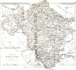
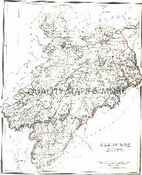
RADNOR 1883
A QUALITY A3 SIZE COLOUR REPRODUCTION FROM AN 1883 ATLAS. LASER PRINTER ON GOOD QUALITY CARTRIDGE PAPER. SENT FOLDED IN A PLASTIC DISPLAY SLEEVE IN A STIFF CARD ENVELOPE AT THE LARGE LETTER RATE. SCALES VARY...
Supplied by: Quality Maps and More Product Ref: QMM-MP421
Rawmarsh 1901
Map of village to north east of Rotherham....
Supplied by: Sheffield & District Family History Society Product Ref: SHE-G70114
RENFREW 1845
A QUALITY A3 SIZE COLOUR REPRODUCTION FROM THE NEW STATISTICAL ACCOUNT OF SCOTLAND 1845. MOST MAPS HAVE THE PARISHES OUTLINED LASER PRINTER ON GOOD QUALITY CARTRIDGE PAPER. SENT FOLDED IN A PLASTIC DISPLAY SLEEVE IN A STIFF CARD ENVELOPE AT THE LARGE LETTER RATE. SCALES VARY [WATERMARKS WILL NOT SHOW ON PURCHASES]...
Supplied by: Quality Maps and More Product Ref: QMM-MP323
Ropley (Village Booklet 20)
The village of Ropley and the parish of St. Peter...
Supplied by: Hampshire Genealogical Society Product Ref: HAM-16020
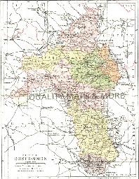
ROSCOMMON 1882
A QUALITY A3 SIZE COLOUR REPRODUCTION FROM PHILIP'S 1882 ATLAS. LASER PRINTER ON GOOD QUALITY CARTRIDGE PAPER. SENT FOLDED IN A PLASTIC DISPLAY SLEEVE IN A STIFF CARD ENVELOPE AT THE LARGE LETTER RATE. SCALES VARY [WATERMARKS WILL NOT SHOW ON PURCHASES]...
Supplied by: Quality Maps and More Product Ref: QMM-MP225
ROSS & CROMARTY 1845
A QUALITY A3 SIZE COLOUR REPRODUCTION FROM THE NEW STATISTICAL ACCOUNT OF SCOTLAND 1845. MOST MAPS HAVE THE PARISHES OUTLINED LASER PRINTER ON GOOD QUALITY CARTRIDGE PAPER. SENT FOLDED IN A PLASTIC DISPLAY SLEEVE IN A STIFF CARD ENVELOPE AT THE LARGE LETTER RATE. SCALES VARY [WATERMARKS WILL NOT SHOW ON PURCHASES]...
Supplied by: Quality Maps and More Product Ref: QMM-MP324
Rotherham 1901
Map of central Rotherham....
Supplied by: Sheffield & District Family History Society Product Ref: SHE-G70115
Rotherham South 1901
Map of area to south of central Rotherham....
Supplied by: Sheffield & District Family History Society Product Ref: SHE-G70116
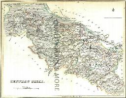
ROXBURGH 1845
A QUALITY A3 SIZE COLOUR REPRODUCTION FROM THE NEW STATISTICAL ACCOUNT OF SCOTLAND 1845. MOST MAPS HAVE THE PARISHES OUTLINED LASER PRINTER ON GOOD QUALITY CARTRIDGE PAPER. SENT FOLDED IN A PLASTIC DISPLAY SLEEVE IN A STIFF CARD ENVELOPE AT THE LARGE LETTER RATE. SCALES VARY [WATERMARKS WILL NOT SHOW ON PURCHASES]...
Supplied by: Quality Maps and More Product Ref: QMM-MP325
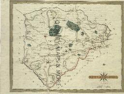
RUTLAND 1787
A QUALITY A3 SIZE COLOUR REPRODUCTION FROM JOHN CARY'S 1787 ATLAS WITH DETAILS OF THE COUNTY OVERLEAF. LASER PRINTER ON GOOD QUALITY CARTRIDGE PAPER. SENT FOLDED IN A PLASTIC DISPLAY SLEEVE IN A STIFF CARD ENVELOPE AT THE LARGE LETTER RATE. SCALES VARY...
Supplied by: Quality Maps and More Product Ref: QMM-MP120R
Rutland 1837 A3 County Map
detailed coloured map [sent in tube]...
Supplied by: The Mclaughlin Guides and Buckinghamshire related books and historic maps Product Ref: BGS-M90

Ryedale Area Map
An outline map of the area covered by the Ryedale Family History Group...
Supplied by: Ryedale Family History Group Product Ref: RFH-MAP-d-001
Scarborough c.1897 Map CD
Stepping Stones publication Scarborough c.1897 Map CD...
Supplied by: S&N Genealogy Supplies Product Ref: SNG-5137
Scotland, Edinburgh Map CD (c.1899)
Stepping Stones publication Edinburgh Map CD (c.1899)...
Supplied by: S&N Genealogy Supplies Product Ref: SNG-5101
Scotland, Edinburgh Map CD c. 1890 & 1895 (2 maps)
Stepping Stones Publication...
Supplied by: S&N Genealogy Supplies Product Ref: SNG-5873
Scotland, Glasgow c.1890 Map CD
Stepping Stones publication Glasgow c.1890 Map CD...
Supplied by: S&N Genealogy Supplies Product Ref: SNG-5102
Scunthorpe & Gainsborough (1824 - 1841) O.S. Sheet number 112
This map also covers: Barton upon Humber, Brigg, Epworth, Goole, and surrounding localities. Scale 1 : 50,000. Publisher Cassini Maps....
Supplied by: Lincolnshire Family History Society Product Ref: LIN-005M