Product Search

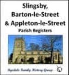
Slingsby, Barton le Street and Appleton le Street - Parish Registers (Burials)
A transcript of the Parish Registers of All Saints, Slingsby Burials: 1813 - 1885 St. Michael, Barton-le-Street Burials: 1813 - 1950 All Saints, Appleton-le-Street Burials: 1813 - 1855
Supplied by: Ryedale Family History Group Product Ref: RFH-PR-cd023
Slingsby, Barton le Street and Appleton le Street - Parish Registers (Burials)
A transcript of the Parish Registers of All Saints, Slingsby Burials: 1813 - 1885 St. Michael, Barton-le-Street Burials: 1813 - 1950 All Saints, Appleton-le-Street Burials: 1813 - 1855
Supplied by: Ryedale Family History Group Product Ref: RFH-PR-d023
Kent FHS CD 02/07 Parish Registers Volumes 1 & 2 Free P&P
The records on the CD have been transcribed by members of Kent Family History Society and are in pdf format. A program such as Adobe Acrobat Reader DC is required. If you have a query about any of our publications please e-mail [email protected] Contents Parish Registers Badlesmere C 1564-1837 M 1563-1837 B 1563-1837 Benenden C 1558-1906 M 1578-1836 B 1710-1906 Boughton-under-Blean C 1784-1812 Coldred…
Supplied by: Kent Family History Society Product Ref: KFS-CD 02
Kent FHS CD 26 Parish Registers Volume 12 Free P&P
The records on the CD have been transcribed by members of Kent Family History Society and are in pdf format. A program such as Adobe Acrobat Reader DC is required. If you have a query about any of our publications please e-mail [email protected] The following indexes are included on the CD Crundale- Baptisms 1556-1915, Marriages 1559-1966, Banns 1754-1941, Burials 1554-1837. Maidstone All Saints-Baptisms…
Supplied by: Kent Family History Society Product Ref: KFS-CD 26
Kent Administrations in the Prerogative Court of Canterbury 1801-1810
The Prerogative Court of Canterbury (PCC) had superior jurisdiction for probate purposes over the south of England from the 14th century until it, and all the other church courts, were abolished in January 1858 and the Principal Probate Registry was founded. The PCC dealt with the grants of probate of wills and letters of administration (admons) of the estates of intestates of those who had goods worth…
Supplied by: Kent Family History Research Product Ref: KFH-13970759
Cutlers of Hallamshire 1624 - 1699
Published transcript of the list of masters and their apprentices. Edited by Hey and Unwin. (Published by University of Sheffield).
Supplied by: Sheffield & District Family History Society Product Ref: SHE-G103
25 years of the Flowing Stream 1977-2004
The material on this CD is in pdf format and a copy of Adobe Acrobat Reader 7 is included. The CD contains scanned copies of the first 25 volumes of the Sheffield & District FHS quarterly journal The Flowing Steam. These cover the period 1977-2004. The journals contain articles, information, research sources and tips, local history, book reviews, members interests and problems and queries. Save…
Supplied by: Sheffield & District Family History Society Product Ref: SHE-G201
Church of the Ascension Oughtibridge Marriages 1868-1986
Transcriptions of marriages conducted at this village parish church in the far north west of Sheffield.
Supplied by: Sheffield & District Family History Society Product Ref: SHE-G423
St Mark Broomhill Marriages 1917-1940, 1963-1988
Transcriptions of marriages at this parish church in the west of Sheffield.
Supplied by: Sheffield & District Family History Society Product Ref: SHE-G430
St Peter & St Paul (Cathedral) and St James (City Centre) Burial Records 1813-1855
Transcriptions of burials at what is now Sheffield Cathedral and the nearby daughter church of St James. Transcriptions of baptisms and an index of marriages at this church are also available for download.
Supplied by: Sheffield & District Family History Society Product Ref: SHE-G615
St Paul's Church (City Centre) 1813-1861 and the Cholera Burial Ground 1832 Burial Records
Transcriptions of burial records of St Paul's in central Sheffield and the common burial ground at Norfolk Park that was created especially for mass burials in the year of the great cholera epidemic.
Supplied by: Sheffield & District Family History Society Product Ref: SHE-G613
Christ Church Attercliffe 1813-1902 Burial Records
Transcriptions of burials in the parish church of Attercliffe, a populous area of east Sheffield. A million pound church built to serve the working class area that grew up around the industry of the lower Don valley during the nineteenth century. The church was destroyed by bombing during the Second World War and not rebuilt.
Supplied by: Sheffield & District Family History Society Product Ref: SHE-G605
Christ Church Gleadless 1839-1953, Christ Church Heeley 1848-1906 and St John Park 1840-1906 Burial Records
Transcriptions of burials in the churchyards of three parish churches built in the nineteenth century to accommodate the needs of Sheffield's expanding population. Files include monumental inscriptions at Christ Church Heeley. Transcriptions of baptisms and marriages at Christ Church Heeley are also available for download.
Supplied by: Sheffield & District Family History Society Product Ref: SHE-G606
St Thomas, Crookes 1859-1973, St Mary Walkley 1880-1901 and Wadsley Church 1835-1903 (7th May 1891 to 11th January 1895 missing) Burial Records
Transcriptions of burials in three parish churchyards in north west Sheffield. The Wadsley records contain a number of burials of patients of the nearby South Yorkshire Lunatic Asylum (later Middlewood Hospital). Burials between 7th May 1891 and 11th January 1895 have not been transcribed because the register cannot be located.
Supplied by: Sheffield & District Family History Society Product Ref: SHE-G617
Beauchief Abbey 1813-1898, Christ Church Dore 1829-1967, Christ Church Fulwood 1839-1908 and St. James Norton 1813-1947 Burial Records
Transcriptions of burials in four parish churchyards serving the far south and south west of Sheffield - With the exception of Fulwood these parishes were part of North-east Derbyshire until a boundary reorganisation in 1934. The Monumental Inscriptions of the gravestones in the churchyard of Christ Church Dore are also available for download.
Supplied by: Sheffield & District Family History Society Product Ref: SHE-G604
Christ Church Pitsmoor 1850-1931, Holy Trinity Darnall 1846-1866, Holy Trinity Wicker 1859, St Lawrence Tinsley 1813-1901 and St Thomas Brightside 1854-1901 Burial Records
Transcriptions of burials in five parish churchyards in north and east Sheffield. The graveyard at Holy Trinity opened and closed after 9 burials because it was decided to use the land for a school building. St Thomas served a working class area in the east end of the city, the heartland of the steel manufacturing industry. The Memorial Inscriptions of the extant gravestones at St Thomas Brightside…
Supplied by: Sheffield & District Family History Society Product Ref: SHE-G607
Christ Church Stannington 1830-1931, Church of the Ascension Oughtibridge 1843-1942, St Mary Bolsterstone 1813-1856 and St Nicholas Bradfield 1813-1899 Burial Records
Transcriptions of burials in the churchyards of four parishes located in countryside to the north and west of Sheffield. Bradfield originated as a daughter church of the parish of Ecclesfield in the middle ages. Transcriptions of baptisms and marriages at the Church of the Ascension Oughtibridge church and the Memorial Inscriptions at St Nicholas Bradfield are also available for download.
Supplied by: Sheffield & District Family History Society Product Ref: SHE-G608
Darnall Municipal Cemetery Burial Records 1859-1901
Transcription of 4,578 burials in Darnall municipal cemetery in the east end of Sheffield. Includes plot references.
Supplied by: Sheffield & District Family History Society Product Ref: SHE-G702
Attercliffe 1903
Map of populous industrial area of Lower Don Valley in north east of Sheffield.
Supplied by: Sheffield & District Family History Society Product Ref: SHE-G70101
Darnall 1903
Map of residential working class area east of central Sheffield.
Supplied by: Sheffield & District Family History Society Product Ref: SHE-G70102
Ecclesfield 1901
Map of village in north of Sheffield.
Supplied by: Sheffield & District Family History Society Product Ref: SHE-G70106
Fulwood and Ranmoor 1903
Map of rural area in south west Sheffield.
Supplied by: Sheffield & District Family History Society Product Ref: SHE-G70107
Grenoside 1901
Map of village in north west of Sheffield.
Supplied by: Sheffield & District Family History Society Product Ref: SHE-G70108
High Green and Thorncliffe 1903
Map of industrial village on northern edge of Sheffield.
Supplied by: Sheffield & District Family History Society Product Ref: SHE-G70109
Nether Edge 1903
Map of suburb to south of central Sheffield.
Supplied by: Sheffield & District Family History Society Product Ref: SHE-G70112